Carpebble: citizen science seismology
Earthquakes we've detected since December 22 2018
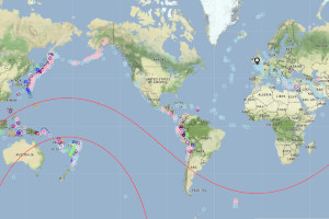
Maps, lists, USGS plate boundary and major fault data
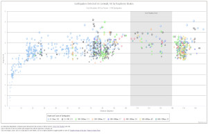
All earthquakes recorded by BGS within 160km (100 miles) of Truro
Five earthquakes that we have detected in Japan, to demonstrate folium - the mapping package
Other links
kml file to view epicentres in Google Earth the kml file on GitHub USGS plate boundaries kmz file.Data sources
The details of earthquake epicentres are mainly obtained from three organisations, follow the links for more info:
- Courtesy of the U.S. Geological Survey USGS,
- European-Mediterranean Seismological Centre EMSC or,
- BGS, British Geological Survey © and Database Right UKRI. All rights reserved.
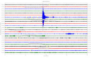
Seismic data also mainly comes from three sources. Other sources will be noted on plots or their accompanying web pages:
- I download daily data for plots of the St Day (RAD67) and Truro School (R7FA5) seismometers directly from these seismometers, which I manage,
- data from seismometers CCA1, HTL and DYA is downloaded from the BGS,British Geological Survey © and Database Right UKRI. All rights reserved.
- data for other seismometers (the ones with 5-figure names) is from Raspberry Shake's web service. Data powered by Raspberry Shake, S.A., a citizen-science project. Please visit raspberryshake.org and join the Citizen Science Community today! DOI: https://doi.org/10.7914/SN/AM
Page updated 2024-03-02.